Hyderabad's Master Plan for Sustainable Urban Growth
 Facing fast urbanization and fragmented development, Hyderabad is preparing for a unified core city master plan set to transform its infrastructure beyond the Outer Ring Road (ORR) by late 2025. This strategy consolidates multiple existing development frameworks into a cohesive blueprint, prioritizing long-term sustainability and equitable growth.
Plan Components
- Zoning & Jurisdiction: The core urban zone within the ORR will focus on high-density residential and commercial hubs. Semi-urban areas between ORR and Regional Ring Road (RRR) will balance development with agrarian needs. The expanded jurisdiction covers 13,000 sq. km, including 100+ mandals across 11 districts.
- Mobility & Connectivity: The plan mainly focus on jam-free road networks, radial roads linking ORR to RRR, and advanced public transit upgrades to increase average speeds from 15 kmph to 35 kmph. Projects under H-CITI will add grade separators, flyovers, and pedestrian infrastructure.
- Economic & Urban Nodes: Strategic placement of industrial zones and knowledge hubs (e.g., Shamshabad as a Fourth City) will diversify employment opportunities and reduce migration pressures.
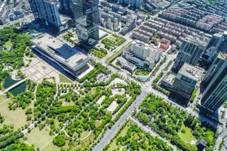
- Blue & Green Infrastructure: The plan aggressively protects 3,600+ lakes and integrates green corridors through advanced mapping (Google Maps, NGRI data) to curb encroachment and ensure ecological balance.
Addressing Challenges
- Coordination Gaps: Previous overlapping jurisdictions (GHMC, CDA, etc.) caused bureaucratic delays. The unified plan mandates alignment of all local agencies under HMDA guidelines.
- Technological Upgrade: Adoption of modern GIS mapping and digital tools will eliminate planning errors from older schemes like the flawed 2030 master plan.
- Public Participation: A structured objection period and transparent gazette notifications will ensure stakeholder buy-in post-draft release.
Future Outlook
With funding for projects like SNDP-II and NDMF already approved, Hyderabad’s core area is poised to become a model for Indian cities balancing hyper-dense urbanization with ecological awareness. The plan’s phased timelines up to 2050 aim to prevent sprawl while accommodating population projections of 15-20 million residents within the expanded HMDA boundaries.